
Eastern US: Persistent, Dangerous Heat with Some Relief Arriving in the Northeast
- Sentinel Weather

- Jun 25, 2025
- 2 min read

The primary weather story for Thursday will continue to be the widespread and dangerous heatwave gripping a large portion of the eastern United States. While parts of the Northeast will finally begin to see some relief as a cold front moves through, the Ohio Valley, Mid-Atlantic, and Southeast will continue to experience extremely high temperatures and oppressive humidity.
Northeast: Temperatures will remain elevated, but a significant cooldown is expected by the end of the day and into Friday for many parts of the Northeast. Cities like New York City, which saw highs in the mid-90s, could drop to around 80∘F (26.7∘C) on Thursday. Boston, which hit 102∘F (38.9∘C) on Tuesday, will also see a substantial drop.
Ohio Valley and Mid-Atlantic: Extremely dangerous heat will persist through Thursday with widespread daily temperature records still possible. Highs in the upper 90s (35∘C to 37∘C) are expected, with heat indices (what it "feels like" when humidity is factored in) reaching or exceeding 100∘F (37.7∘C) to 105∘F (40.5∘C). Overnight low temperatures will remain elevated, providing little relief.
Southeast: Temperatures will remain well above average across the Southeast, with highs in the 90s (32∘C to 37∘C) and heat indices potentially exceeding 100∘F (37.7∘C). Areas like southeast Louisiana and south Mississippi, particularly along the I-10/12 corridor, could see heat indices up to 107∘F (41.7∘C).
Severe Thunderstorm and Flash Flood Threat:
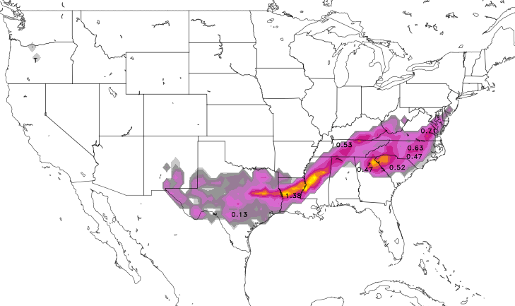
Several areas of the country will face a risk of severe thunderstorms and heavy rainfall on Thursday:
Southern High Plains and New Mexico: Heavy rain and flash flooding will be a significant concern, especially in New Mexico, where monsoonal moisture continues.
Central Plains into the Lower Great Lakes: Scattered strong thunderstorms are possible, with damaging wind gusts being the primary concern. Daytime heating and a moist air mass will contribute to instability.
Southeast: Scattered strong storms are also possible across much of the Southeast. While predictability is a bit low, localized damaging gusts are possible, particularly from Mississippi into northern Alabama and northeastward across the Appalachians, Virginia, Maryland, and western Carolinas.
Upper/Middle Mississippi Valley and Upper Great Lakes: There's a continued potential for severe thunderstorms and excessive rainfall.
Other Regions:
Southwest: Monsoonal moisture is likely to increase over the southern and central Rockies and Plains, potentially leading to increased chances of showers and thunderstorms. While the most extreme heat has shifted eastward, the Southwest will still experience warm temperatures.
Northern California and Pacific Northwest: Conditions will generally be cooler and less active after a cold front moved through, bringing some rain and mountain snow.
High Plains: Temperatures in the High Plains are generally forecast to be a few degrees below average.
In summary, tomorrow will see a stark contrast across the US. The eastern half will continue to battle a prolonged and dangerous heatwave, especially south of the Northeast, where some initial relief is arriving. Meanwhile, significant thunderstorm and flash flood threats exist across portions of the Southern Plains, New Mexico, Central Plains, and Southeast.


Comments