
'Ring of Fire' could create flooding for parts of the U.S.
- Sentinel Weather

- Jul 16, 2025
- 2 min read
High pressure will remain in place across the eastern half of the country and be centered over the Tennessee river valley. The clockwise flow around this high will continue to move waves of rain and storms around the edge of it. This is often referred to as the Ring of Fire. Locally heavy rain and strong storms will be possible in some areas that could lead to dangerous flooding.

Gulf Coast Tropical Threat and Associated Flooding:
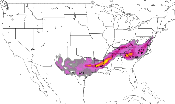
Heavy Rainfall and Flash Flooding: Invest 93L will continue to move across the northern Gulf and across south Louisiana. While tropical development is not expected there will be pockets of heavy rain. Rainfall totals of 4 to 8 inches are expected in south-central Louisiana, with isolated amounts up to 15 inches possible, significantly increasing the risk of flash flooding, especially over already saturated ground.
Widespread Showers, Thunderstorms, and Flood Risk:
Central Plains to Mid-Atlantic: A slow-moving frontal boundary extending from the Central Plains, through the Mid-Mississippi Valley, Ohio Valley, Central Appalachians, and into the Mid-Atlantic, is the primary driver for widespread showers and thunderstorms. These storms are capable of producing heavy downpours and flash flooding.
Appalachian Flood Vulnerability: The mountainous terrain of the Appalachians remains highly susceptible to flash flooding. With abundant moisture streaming in from the Gulf and Atlantic, prolonged and repetitive thunderstorms in this region could lead to significant rainfall accumulations and dangerous flood conditions.
Mid-Atlantic Flood Watches: Areas within the Mid-Atlantic, including portions of the Washington D.C. metro area, are under Flood Watches through early Thursday morning, indicating the potential for heavy rainfall and flooding.
Severe Weather Potential:
Isolated Severe Storms: Isolated severe thunderstorms are possible across parts of the Central Plains, Midwest (including eastern Colorado to the Lower Missouri Valley and parts of the Lower Michigan and Ohio Valleys), and the Mid-Atlantic states. These storms have the potential to produce damaging winds and large hail.
This active pattern looks like it will continue through much of next week as well with another tropical disturbance possible across the northern Gulf of America.


Comments